


exp_J2 La Bourboule - Roche de Vendeix- cascades.gpx

semaine
User
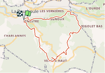

Length
9.6 km

Max alt
1169 m

Uphill gradient
456 m
Km-Effort
15.7 km

Min alt
859 m

Downhill gradient
461 m
Boucle
Yes
Creation date :
2019-12-21 16:23:01.287
Updated on :
2019-12-23 16:27:07.514
3h30
Difficulty : Difficult

FREE GPS app for hiking
 SityTrail
IGN / Geographical institutes
SityTrail Plus
The world is yours!
About
Trail On foot of 9.6 km to be discovered at Auvergne-Rhône-Alpes, Puy-de-Dôme, La Bourboule. This trail is proposed by semaine.
Positioning
Country:
France
Region :
Auvergne-Rhône-Alpes
Department/Province :
Puy-de-Dôme
Municipality :
La Bourboule
Location:
Unknown
Start:(Dec)
Start:(UTM)
479689 ; 5048028 (31T) N.
Comments